John Gangemi, Past & Present

John Gangemi, of the consulting firm ERM, is the lead recreation consultant for Edison in its KR3 relicensing proceeding.

Gangemi used to work for American Whitewater. In fact, he signed the 2002 Settlement Agreement with Edison regarding whitewater flows on the Upper Kern on AW’s behalf — i.e., he is responsible for the awful whitewater release schedule we have now.

Gangemi misled our boating community about that settlement, saying the agreement “increase[d] the number of days for whitewater releases to 39.” In fact, as Edison conceded in 2014, the number of days when water would potentially be released from diversion was only 14. As an added impediment to flows on the Upper Kern, Gangemi agreed to a brand new “tunnel maintenance flow” that guarantees the first incoming 300 cfs to the project before any rec flows are released. Gangemi admitted he never saw the “study” that purported to justify that flow. (09DEC2020 TWG meeting. The study has since been “lost,” according to Edison.)

In the present KR3 proceeding, Edison has taken stances diametrically opposed to those Gangemi took while working at AW. As the lead recreation consultant who has defended Edison’s study proposals in public proceedings, one can reasonably surmise that Gangemi contributed to if not wrote Edison’s proposals in their entirety. Consider these instances:

  • Edison’s REC-1 whitewater boating study plan contains the following objective: “Document potential conflicts of boating flows with other recreation users and identify strategies to mitigate those conflicts.(Edison PSP REC-1 at 1.) But in 2002, Gangemi wrote, “Scheduled whitewater releases . . . are compatible with other recreational uses of the river as has been demonstrated in countless other relicense proceedings across the country. Angling use and whitewater recreation are compatible uses despite vociferous arguments to the contrary. No study in any relicense proceeding has demonstrated that flow fluctuations from whitewater releases decrease the catch rate on the same day of the release.” (FERC eLibrary No. 20021009-5038 at 10.) He also wrote that the “Flow needs of other recreational users should . . . not pollute the results of this [boating] study. Those different needs if they exist will need to be balanced in the license application. Adding them here would taint the results of this study . . . .” (FERC eLibrary No. 20021107-0115 at 54.)

  • In opposition to KRB’s request for an on-water boating study, Edison wrote, “A controlled flow study below Fairview Dam would be limited to collecting data for a narrow range of flows, thus failing to meet the study objectives as described in Whittaker et al. (2005). (Edison’s PSP at 23.) However, Gangemi co-authored the Whittaker guide, which flatly contradicts this “narrow range of flows” objection: Whittaker notes that only “[t]hree to four flows are commonly assessed in these [on-water] studies,” and then makes clear that these studies “work best when they are focused on discrete flow ranges where more precision is needed.” (Whittaker (2005) at 26-27), which is precisely what KRB has argued for: an on-water investigation into the most controversial levels of flow: 300 to 700 cfs.

  • Edison also objected to an on-water study because of “the unpredictable snowpack and associated flows during the ILP study period. (Edison’s PSP at 24.) However, the Whittaker guide plainly states that “In some cases, the study may capitalize on natural flows instead of controlled flows.” (Whittaker at 26.) That guide also states that “Some rivers have extensive recreation use that is clearly flow-dependent and affected by project operations; here more intensive and detailed efforts are necessary.” (Whittaker at 8.)  

  • In response to KRB’s contention that a vast number of boating days is lost due to project operations, Edison maintained: “the made statement above that, “..whitewater recreation is lost to project operations” is not factual, as the current Project flow regime represents the baseline condition considered for analysis in this relicensing not conditions that pre-date the Project before it was built.” But in 2003, Gangemi wrote: “Clearly, [Edison’s] network of diversions, canals and powerhouses has a cumulative effect on water quantity and flow dependent recreation.” (FERC eLibrary No. 20030829-5013 at 2.) Also: “The Borel Hydroelectric Project’s combination of diversion structure, canal and powerhouse significantly alters the instream flow in the eight-mile natural river channel below Isabella Reservoir.  Accordingly, this flow alteration limits downstream river recreational opportunities and in particular whitewater boating.” (FERC eLibrary No. 20040218-5036 at 4.)

  • Edison has attempted to marginalize the 1994 on-water study for KR3 as “opportunistic” requiring “mobiliz[ation] on short notice” and lacking the “substantial improvement in whitewater study design and planning as evidenced in the Whittaker et al. (2005) publication.” (SCE RSP at 2.3.2.7.) But in the Borel proceeding, Gangemi specifically characterized the 1994 study as a “Controlled Flow Whitewater Stud[y like others that] have been undertaken in the relicensing of numerous FERC projects.” (FERC eLibrary No. 20030423-5019 at 11.) He further described it as “the preferred method for evaluating instream flows for whitewater recreation.” (FERC eLibrary No. 20030423-5019 at 10-11.)

  • Regarding its preference for surveys over an on-water controlled flow boating study, Edison wrote: “The online flow comparison survey is not limited to the unpredictable snowpack and associated flows during the ILP study period. . . . The goal of the survey is to improve the precision for developing flow preference curves for a variety of watercraft types for the respective whitewater segments in the 16-mile Fairview Dam Bypass Reach.” (Edison’s PSP REC-1 at 6.) But during the Borel relicensing proceeding, Gangemi scoffed at the notion that surveys were sufficient: “the Licensee failed to conduct the appropriate [on-water] instream flow studies capable of identifying the minimum acceptable and optimum flows for flow dependent recreation including wading, swimming, tubing and whitewater boating. The Licensee elected instead to devote energy to surveying existing users in the Kern River on their preferred flows.  Surveys were conducted over the 2001 and 2002 summer seasons. The Licensees’ consultants provided summaries to the stakeholder group of survey results in 2001 and again in 2002. On both occasions, the stakeholder group pointed out significant errors in the data. In recognition of these errors, and the inability to correct them, the stakeholder group recommended at an October 2, 2002 meeting in Kernville that SCE undertake a controlled flow study as originally requested in comments on the FSCD by American Whitewater to identify minimum acceptable and optimum flows for flow dependent recreation.” (FERC eLibrary No. 20030829-5013 at 3.) He also wrote, “recreation surveys and SNF manifest data were not sufficient for analysis and developing whitewater PM&E’s for the Borel project. The conclusions contained in the Final License Application are based almost entirely on the flawed survey data and SNF manifest data.  Furthermore, it became apparent that stakeholders were unable to evaluate the adequacy of SCE’s proposed augmentation plan until a Whitewater Controlled Flow Study identifying the minimum acceptable and optimum flows was conducted.” (FERC eLibrary No. 20040218-5036 at 6.) And again: “The license application is deficient as a result of SCE’s insistence to apply survey methods rather than conduct the appropriate Whitewater Controlled Flow Study. SCE’s license application fails to present a defensible range of boatable flows supported by scientific study.” (FERC eLibrary No. 20040218-5036 at 7.) Gangemi said he “repeatedly directed SCE to conduct a Controlled Flow Whitewater Study as the recommended method for identifying minimum acceptable and optimum flows for whitewater recreation in the bypass.” (FERC eLibrary No. 20030423-5019 at 5.) Finally, Gangemi stated: “The controlled flow method enables the researcher to identify with significant accuracy the minimum acceptable and optimum flows for whitewater recreation. Although alternate methodologies have been used in other FERC proceedings none have proved as reliable and accurate as the controlled flow methodology.” (FERC eLibrary No. 20030423-5019 at 8.) An on-water study is “the most definitive method” for identifying minimal and optimal flows. (FERC eLibrary No. 20021107-0115 at 48.)

  • Finally, Gangemi wrote during the Borel proceeding, “In the context of a relicense proceeding the stakeholders utilize [study] results for the respective forms of recreation to advocate their interest in flows. SCE’s proposal would fold this negotiation phase into the actual study thus compromising the integrity of the study. . . . I’d rather know that the study results represent objective data as opposed to negotiated results.” (FERC eLibrary No. 20021107-0115 at 47.) In the KR3 proceeding, Gangemi tried to turn the Level 2 focus group into a negotiation.

We could go on, but you get the picture: Gangemi is not some type of independent analyst or pro-boater social scientist, no matter how he tries to represent himself locally. Rather, he has been hired by Edison, is being paid with money earned from the KR3 diversion, and his carreer will fourish if he holds the line against substantially increased whitewater flows.

Brett's Comments at the August 02, 2023 KR3 Scoping Meeting

I’m Brett Duxbury. You all know me, but not everyone might. I’ve been a resident of Kernville for 16 years. I’m on the Board of Kern River Boaters and the Kern River Fly Fishing Council — both are California public benefit corporations with federal 501c3 status.

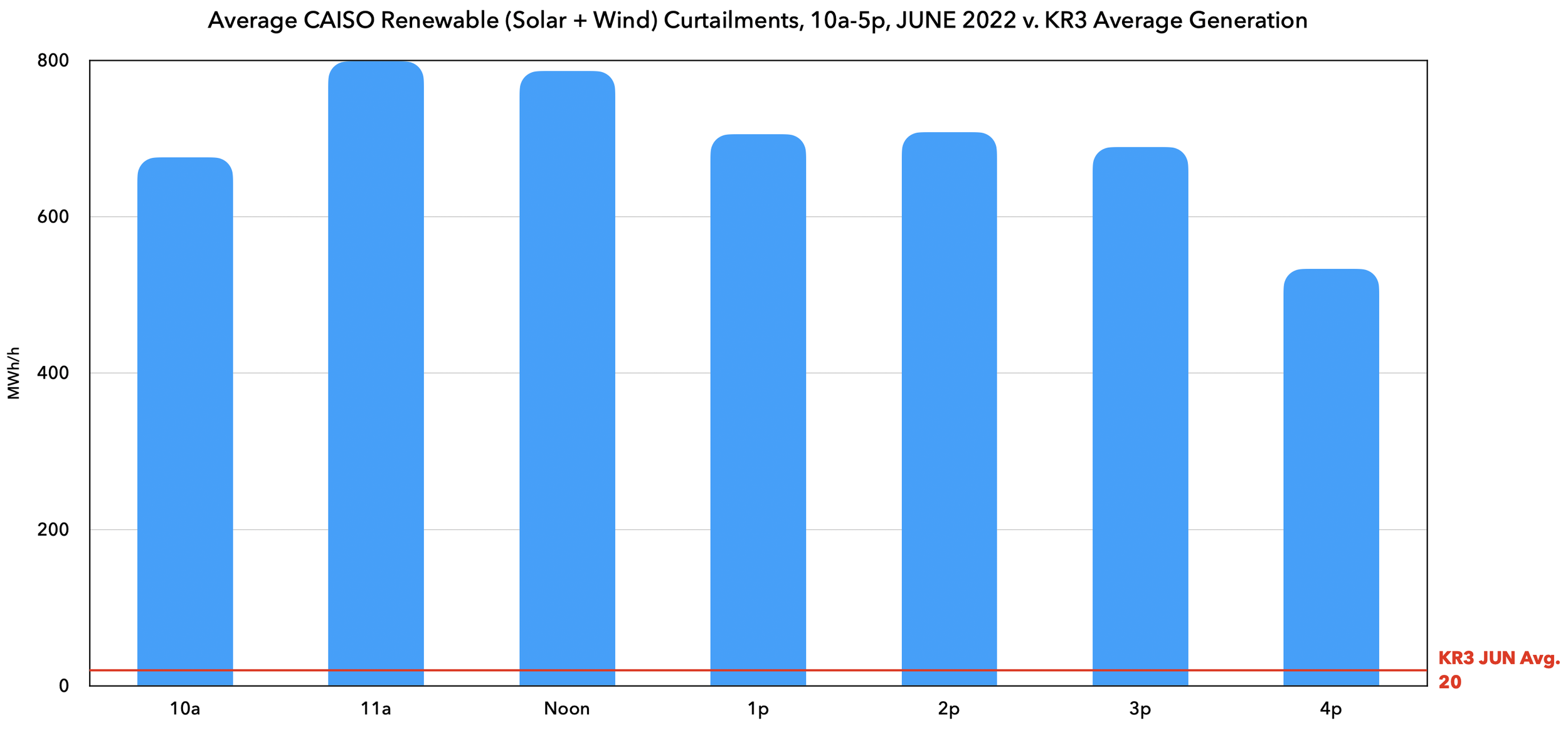
I won’t be making an argument for decommissioning like I did with KR3. I am not anti-all-hydro, just anti-pure-Run-of-River hydro, because the latter makes its power in spring, when demand is low and there’s a solar glut, and by late summer when our state needs all the energy it can get, its fuel — snowpack — has been spent.

Storage hydro on the other hand has positives for flood control, agriculture, time shifting energy to when its needed, and actually provides recreation rather than just taking it away all the time.

KR1 is a hybrid: it is Run-of-River, but it runs off storage — the Isabella reservoir — and so unlike KR3, KR1 helps with the steep net ramp and blackout potential in late summer. It also does not dewater a Wild & Scenic River.

The key with KR1 is to regulate it like you’re supposed to: in line with modern social values — not the values of Edison’s old-school hydro managers that tend to make their way through the agencies. If you make sure there remains plenty of water in the river for the public good, I will support this relicensing. Shocking, No?

GEOLOGICS:
I would like to comment on the project’s potential and continuing impacts on Highway 178 between here and Isabella, commonly called “The Canyon.”
The project conveys 1.5 million of pounds of water per minute hundreds of feet above 178.
In August 2013 the conveyance‚ including the emergency spillway, failed during a storm.
An Adit and the Forebay overflowed while Edison continued to pump water, adding fuel to the fire, so to speak. This caused two massive landslides across 178 and closed both lanes of the canyon for about two weeks.
The result of all this was that CalTrans sent Edison a bill for a half million dollars (and Edison wiggled out of it thanks to its political connections) and FERC increased the project’s hazard rating from “low” to “significant.”

I have two points to make about this.
First, a hazard rating of “significant” does not envision the potential for loss of a single life from a failure like this.
That is as out of touch with reality as FERC’s original judgement that the project posed a “low” hazard.
Cars drive fast on 178, and there’s lots of them. It is only by luck that those landslides didn’t kill anyone.
Edison admits it didn’t anticipate this failure, and there is no reason to think this or similar modes of failure can’t happen again.

Conveying millions of pounds of water above the unsuspecting public on a major highway is inherently dangerous to human life.
This project’s hazard rating should be increased to High in the public interest.

My second point concerns the continued closures of 178 from time to time. As we all know from this year’s long closure, that highway is key to linking the Kern River Valley with the outside world.
But it is all-too-frequently closed for shorter periods from smaller rockslides. Myself and others think most of those closures are near the sites of the two landslides Edison caused in 2013 — below Adit 17/18 and the Forebay.

We suspect the hillside stabilization Edison was ordered to undertake was not fully successful.
I ask that an independent engineer perform an analysis of CalTrans 178 closure and repair data.

If that shows a disproportionate number of closures below the Adit and Forebay, the engineer should re-evaluate the hillside for further stabilization measures, which you should then direct Edison to perform prior to issuing a new license.

AQUATICS: FISHERY
According to the rank and file of the Kern River Fly Fishers Club, there used to be bass in this section of river. Folks could pop up after work and enjoy a few hours of fishing.
That incredible resource is not gone. It seems the sediment management plan dreamed up by Edison’s consultants destroyed that fishery.
I understand the plan was approved by all the agencies, but just like FERC’s safety rating, agencies don’t always get things right, and sometimes make huge mistakes. We can’t afford another one here.
Make Edison haul their sediment away, provide radically increased minimum flows, and order Edison to reestablish a viable fishery.
And be skeptical of Edison objections purportedly based on the environment; Edison is adept at using those as a fig leaf to protect their take of water from the river, like they do with the Hatchery up at KR3.

RECREATION
It is 2023, right?
Flow information for every other river segment is available online — even at the Kern Canyon Project.
Why as a boater do I have to sit through a three-minute phone message that is barely intelligible to find the flow below Democrat dam? (Really, try it out when you have a chance: 760-537-6356.)
I have to do that because Edison never gives an inch more than its license demands. And it often finds a way to give less — look back into the portage and fish ladder issues at Fairview Dam.
We need instantaneous online flow information below Democrat dam to safely use the river. Please provide it.

LAND USE & AESTHETICS
The lower Kern has been incredible to look at this year.
That has not been the case the last three years or any time the project reduces the river to fish flow, which is usually a paltry 15 cfs while the project takes 400+.
At those times you see stagnant pools, lots of algae, and where there is moving water, it is narrow, slotted, slow, and hard to see through the road blast.
There was Facebook video last year of a low flying helicopter over fish flow and you could barely make out any patches of water — it looked more like a rock quarry than a river.
According to CalTrans, 2-3 million people drive the canyon one-way each year. Those people — and the day users — deserve something better to look at than a dead river.
I ask that you carefully study aesthetics — not with easily manipulated survey data but with a science-based controlled flow study — and then radically raise minimum flows to keep this looking like a healthy river all year long.
That would also improve water quality, the fishery, and day use recreation, but I know those are separate resource issues — See how they divide and conquer project effects to isolate them and make them look small?

ENVIRONMENTAL JUSTICE
I thought you were supposed to analyze for economic justice as well as environmental? This comment applies to both.
You will probably find the day users of this river disproportionately come from communities suffering economically and environmentally.
There are limited opportunities for quality outdoor recreation around here at the price of this river — about $10 for a family — and the river offers improved air quality and an opportunity to get away from a desert littered with industry and surrounded by big Ag to a better setting (when there’s water), if only for an afternoon.
It follows that the project’s effects on river aesthetics, water quality, and the fishery disproportionately affect these communities.
You should strive for a radically more equitable balance on flows between the public and the powerplant — Heck: make a mistake on the public’s side for a change instead of Edison’s.

Wind+Solar Curtailment and the KR3 Hydroproject

Summary: Due to the increased and increasing use of solar and wind power, which typically has to be consumed by the end user as soon as it is generated, California's grid already creates too much power during some times of the day. This is particularly true in the winter, spring, and fall months, when demand for power to cool homes is lower. During these times, California's solar and wind power generating resources are deliberately turned off to prevent overloading the grid. Yet inexplicably, KR3 remains online generating unnecessary and unneeded power. This post explains why KR3 should be taken offline during the hours of 10am and 5pm from February to June and September to November. During these periods of vast excess power generation from other sources, the highest and best use of the Wild and Scenic North Fork Kern is not power generation — there is too much of that already — but natural flows for recreational use and environmental protection.

The deployment of renewables in California has been incredibly successful to this point on our state’s path to a green grid. However, it has brought along an unanticipated consequence: the threat of over-generation — that is, generating more power than the grid can handle. All power must serve a load, and system operator CAISO works tirelessly to equalize supply with demand. Balance has become more difficult with the deployment of renewables like wind and solar, which increasingly threaten to swamp the grid with too much energy production during daylight hours, leaving supply well above the levels of demand. That’s the risk of over-generation.

CAISO’s main strategy to prevent over-generation and balance supply with demand is called “curtailment,” which does what it says: curtail (lessen) the amount of generation by modern solar and wind generators whenever the grid is threatened. We’ll let CAISO speak for itself on the matter:

“Curtailment is the reduction of output of a renewable resource below what it could have otherwise produced. . . . Curtailing renewables results in lost opportunities for clean resources to generate all of the carbon-free power that otherwise could be produced. . . . Curtailing renewables is counterintuitive to California’s environmental and economic goals. It reduces the output from the renewable plants in which the state has invested, and could result in overbuilding renewable plants to ensure that the state meets its 50-percent renewable mandate

So curtailment as a strategy, while effective in keeping the grid safe, is not a desirable public policy. One of CAISO’s strategies to reduce the need for curtailment is to “reduce minimum operating levels for existing generators, thus making room for more renewable production.” In other words, reduce production to make room for wind and solar, keeping those more modern and rational generators online and profitable, so more will be built. That’s where the KR3 hydroproject should come in.

KR3 is a contributing cause to curtailment. Whenever over-generation is threatened, KR3’s production of electricity only adds to that threat, and causes modern generators like wind and solar to be sidelined to ensure that supply and demand balance out. The times when over-generation are threatened are ripe for reducing the output of KR3, “thus making room for more renewable production,” in the words of CAISO.

When are these times? According to the data, significant curtailment generally prevails any time between 9am and 7pm. But it massively prevails between 10am and 5pm. This chart depicts the average daily curtailment for each hour in 2022:

Note we have included for reference the theoretical maximum rate of production at KR3: 36.8 kW. KR3 almost never achieves that rate as the availability of sufficient “fuel” — 600 cfs of diverted river water — is contingent and unpredictable. Indeed, as the following chart shows, KR3 routinely generates at a small fraction of that rate. KR3 generates at its highest rates in spring, when demand is low and curtailments are high. And in all but the wettest of years, KR3 is nowhere to be found during late summer and early fall, when demand is high and the potential for “loss of load” (blackouts) is acute:

Back to the issue of curtailment, it is important to note the phenomenon’s seasonal component in addition to its hourly nature. In winter and especially in spring, demand is relatively low, forcing widespread curtailment of wind and solar assets. The following graph depicts average daily curtailments, by hour and by quarter, for the year 2022. Note how the figures begin to dwarf the KR3 reference line. Indeed, each horizontal axis line represents a ten-fold increase above the theoretical maximum power that KR3 is capable of producing:

Combining those two aspects of curtailment — hour of the day and time of year — is revelatory. The following chart depicts CAISO curtailments in 2022 between the hours of 10am and 5pm for each month of the year:

That chart shows the energy produced by KR3 is simply not needed during the hours of 10am and 5pm in February, March, April and May. Those curtailments occur at a scales of twenty to sixty times the maximum amount of power KR3 is theoretically able to produce.

But KR3 rarely gets close to producing that maximum. The contingencies of a fluctuating annual snowpack, unpredictable weather patterns, and the need for maintenance outages all conspire to limit KR3’s production to an average rate over the last 22 years of available data of just 12.0 MW:

Let’s compare the average monthly rates of production for KR3 against the massive quantities of curtailment imposed between the hours of 10am and 5pm in 2022. We’ll start with January. You can see that curtailments between 10am and 4pm (one hour short of 5pm) are more than 20 times greater than KR3’s average (9.4 MW) for that month. Again, the horizontal scale lines represent ten-fold multiples of KR3’s monthly average rate of production:

In February, renewable curtailments skyrocket, while KR3 eeks out a little more power (12.7 MW rate). Curtailments during the relevant hours that month were more than sixty to one hundred times larger than KR3’s production:

Even as KR3 increased its rate to 15.4 MW in March, curtailments again went higher, sidelining wind and solar in amounts seventy to one hundred forty times larger than KR3’s rate of output:

We’ll play out the string from here to round out the rest of 2022:

The following chart summarizes preceding charts with both the minimum and maximum multiples of renewable curtailments between 10am and 5pm by month against the KR3 average rate:

We believe these figures show that the energy KR3 produces during the hours of 10am and 5pm is not useful to society from February to June and September to November. It makes no sense to dewater the Wild and Scenic North Fork Kern during those hours when at least 25 times (and most often much, much more) the generating power of KR3 is sitting on the sidelines. And don’t forget, according to CAISO the scale of curtailments is expected to increase over the years as more and more wind and solar come online.